
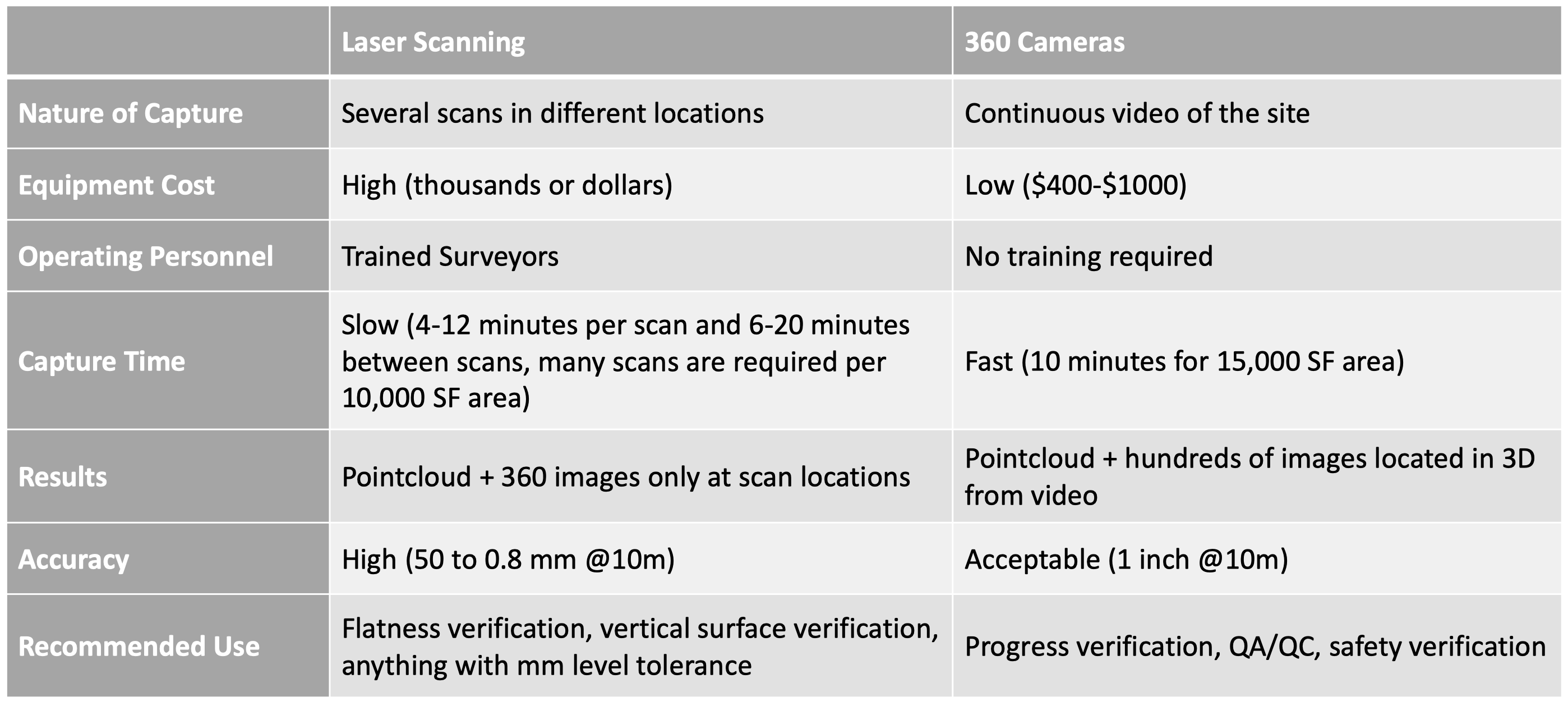
You can create 3D Point Clouds in Reconstruct. These point clouds represent a similar result (with some specific differences) to the output of a laser scanner. The table below compares the point clouds created in Reconstruct using laser scanning versus using 360 cameras. This comparison will help you decide when to use each.
What Are Point Clouds?
Point clouds contain millions of points floating in 3D space. You can think of a point cloud as a pixelated 3D photo, where each individual pixel is located in a unique 3D location in space and has a different color. Displaying all these points together in their respective locations provides a 3D model that reflects reality, hence the naming "Reality Models". These point clouds can be created via several methods, the top two of which are Laser Scanning and Photogrammetry.

Laser Scanning
Laser scanning creates point clouds by emitting a laser beam that bounces on an object and returns back to the scanner. The scanner can then estimate the distance between the scanner and the object that the beam bounced on by measuring the time it took the laser to return to the scanner. These types of laser scanners are called Time Of Flight (TOF) scanners. The main benefit of this method is that it is very accurate in small spaces. However, it has its limitations.
- Laser scanners are expensive ($16K to $250K).
- They must be operated by trained surveyors who understand survey concepts and theories.
- It takes a significant amount of time, usually hours or even days to capture a job site.
- It requires post-processing of the captured data on very powerful and expensive computers in order to stitch separate scans into a unified point cloud.
The characteristics of laser scanning make it ideal for final documentation of the important parts of a project or to verify the flatness of surfaces. However, it requires more resources to cover the equipment, training, and experienced labor, which makes it not ideal for weekly progress tracking.
Reconstruct 360 Cameras (Photogrammetry)
On the contrary of laser scanning, Reconstruct utilizes 360 videos to generate dense point clouds of construction indoor spaces. Using Reconstruct to generate the point clouds provides a different set of benefits and limitations.
- The equipment is more affordable ($400 for 360 camera, $150 stabilizer, $20 memory card).
- There is no need for surveyors or trained engineers. The camera can be operated by anyone after a 15-minute training video.
- It is fast. On average, you can cover 1,500 SF per minute of capture.
- Post-processing mostly happens on the cloud so there is no need for expensive computers nor a need to oversee the process.
360 cameras are ideal for weekly progress and safety tracking as well as basic QA/QC. The downside is the greater margin of error, which is less ideal for final documentation and for projects requiring high accuracy and precision.
Comments
0 comments
Article is closed for comments.