
Reconstruct organizes your photos by 3D location and creates 3D reality models that can be used for inspection and coordination. Capturing images for the purpose of 3D reconstruction and 3D visual documentation is different from capturing photos and videos for demos or visual inspection. This article explains how to capture better data for 3D reconstruction and is for anyone interested in capturing photos for the purpose of 3D reconstruction, including drone pilots, construction managers, and inspection engineers.
To create a 3D point cloud from images, the computer must perform three main tasks: (1) match similar features in image pairs; (2) solve for the pose of each camera relative to the others using these matches; and (3) compute 3D points from the set of localized cameras. To match two photographs, they must be taken from different positions with similar angles and should view around the same scene points. To get dense and accurate 3D point clouds, each scene point should be viewed by at least five images.
Model Quality
The quality of your reality model is controlled by a few factors that can be controlled during the capture:
- Coverage: Captured drone images should cover 100% of the area needed in the reality model. If a certain part of your project did not show in the images, it will not be in the 3D Reality Model.
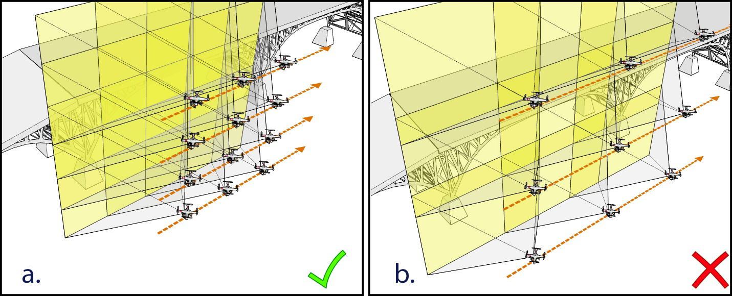
- Overlap: Images captured for photogrammetry should have more than 70% overlap. This means that 70% of the area of each image should be covered in the next image (see illustration below).
-
Image Quality: Images captured for photogrammetry should be sharp and of high quality. Use the highest possible resolution of your drone camera (minimum 12 MP), and make sure your camera settings are suitable for the environmental conditions of your capture. In general, avoid the following:
- Motion blur
- When images are blurred due to the movement of the drone.
- This usually happens when lighting is too low, or when the drone is moving too fast.
- Out-of-focus images
- Make sure that you can see sharp images in the drone flying software during the capture.
- Edges and features should be sharp and clear.
- Overexposed or underexposed images
- The exposure of your images controls that amount of details visible in shadows or highlights. Make sure that your exposure is configured for the type of lighting that you have during the capture.
- Lack of sufficient overlap
- Remember to do 70%-80% overlap in all directions
- Homogeneous surfaces (sand, plain walls, crops, etc.)
- Avoid capturing plain surfaces (without features) as these confuse the 3D Reconstruction algorithms and cause errors.
- Motion blur
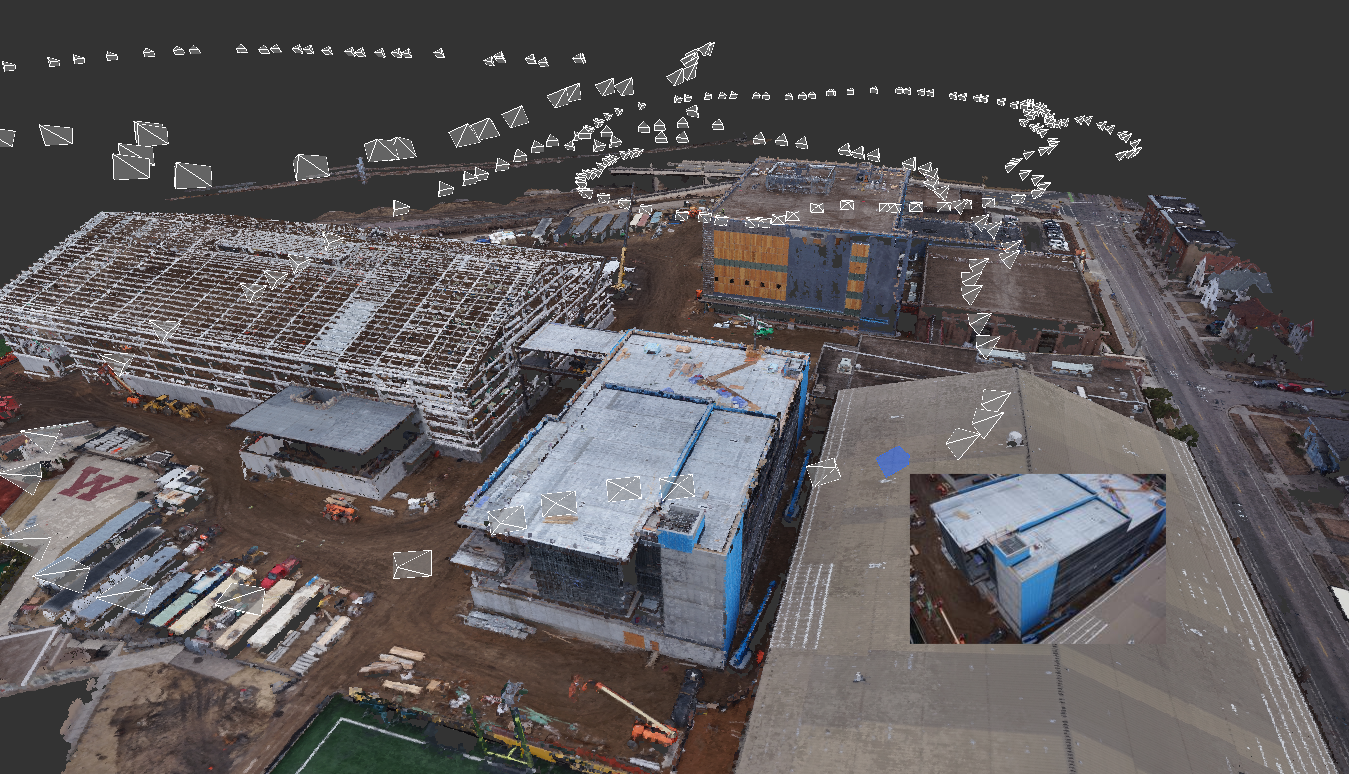
- Side images (oblique): these are images captured by the drone to look at the sides of your building. They are very important to improve the quality of the resulting reality model. The screenshot below shows a completed Reality Model in Reconstruct. White pyramids are displayed in the location of each image used in the generation of that reality model.
Capture Planning
There are specific requirements that must be met in an image set to produce a good reality model in Reconstruct. These requirements include capturing the following sets of images for every project:
a) 1st Mapping Grid (Required):
- This set of images is designed to provide comprehensive coverage of the whole area that needs to be captured.
- Camera looking top-down (Nadir)
- 70%-80% overlap between images in both directions
- 100-150 feet above the highest structure and/or equipment (including cranes, and some nearby buildings). Make sure the selected altitude is safe before you fly.
- Captured in a lawn-mower pattern zigzagging over the desired capture area.
b) 2nd Mapping Grid (Either this or the next set of images is required, doing both provides better quality):
- This set of images is designed to supplement the 1st set of images and provide additional details to all or part of the project area.
- Camera looking top-down (Nadir) or at an angle (60-degree) but make sure to avoid showing the horizon or sky in these images. If you are planning to add any of the two optional oblique image sets, then it is better to do this set with Nadir images. Otherwise, a 60-degree angle is better.
- 70%-80% overlap between images in both directions
- 50-75 feet above the highest structure and/or equipment (including cranes, and some nearby buildings). Make sure the selected altitude is safe before you fly.
- Captured in a lawn-mower pattern zigzagging over the desired capture area.
c) 1st Oblique Circle (Either this or the previous set of images are required, doing both provides better quality):
- This set of images is designed to supplement the aforementioned two and provide more details on the sides of any structures in the project.
- Camera looking at the highest angle that does not show the horizon or sky.
- If you are planning to do this set, then capture the second mapping grid in Nadir orientation.
- 70%-80% overlap in the horizontal direction
- 50-75 feet above the highest structure and/or equipment (including cranes, and some nearby buildings). Make sure the selected altitude is safe before you fly.
- Can be captured by manually flying in a closed circle around a structure, while setting the drone to capture an image every 2 seconds. It can also be captured using the "Point of interest" feature in the DJI Go app.
d) 2nd Oblique Circle (Optional):
- This set of images is designed to supplement the aforementioned sets and provide more details on the sides of any structures in the project.
- Camera looking at the highest angle that does not show the horizon or sky.
- If you are planning to do this set, then capture the second mapping grid in Nadir orientation.
- 70%-80% overlap in the horizontal direction
- 100-150 feet above highest structure and/or equipment (including cranes, and some nearby buildings). Make sure the selected altitude is safe before you fly.
- Can be captured by manually flying in a closed circle around a structure, while setting the drone to capture an image every 2 seconds. It can also be captured using the "Point of interest" feature in the DJI Go app
Capturing all four sets of images guarantees the highest quality reality model. However, a plan including (a) and either (b) or (c) is sufficient.
Comments
0 comments
Please sign in to leave a comment.